Wisconsin Valley
Improvement Company
Improvement Company
Wisconsin River Centennial Canoe Trail
 The Wisconsin River Centennial Trail was established in 2007
to commemorate WVIC’s 100th year of coordinating flow on the Wisconsin. The
primary purpose of the trail is to provide users of the Wisconsin River information
and visual representation of all the portages on the Wisconsin River along with
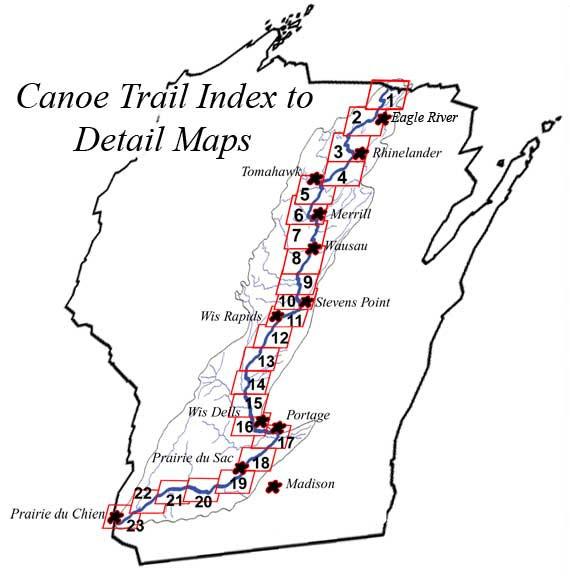
descriptions of amenities along the river important to canoeists and kayakers. Originally, 23 maps were developed to cover
the entire river, and 27 aerial maps of individual portages were developed with
assistance provided by member companies. Permission was obtained from several
townships, counties, communities and the State of
The Wisconsin River Centennial Trail was established in 2007
to commemorate WVIC’s 100th year of coordinating flow on the Wisconsin. The
primary purpose of the trail is to provide users of the Wisconsin River information
and visual representation of all the portages on the Wisconsin River along with
descriptions of amenities along the river important to canoeists and kayakers. Originally, 23 maps were developed to cover
the entire river, and 27 aerial maps of individual portages were developed with
assistance provided by member companies. Permission was obtained from several
townships, counties, communities and the State of
Wisconsin to place mile marker signs at
obvious landmarks along the river. 56 mile marker signs were placed from Lac
Vieux Desert down to Prairie du Sac. The Lower Wisconsin State Riverway Board
denied permission to place any signs in the LWSR. Signs were placed at take-out
locations at every portage, on several bridges or on the right-of-way, and at
other locations where placement was advantageous to river users.
In 2020, staff completed an update of the entire information
network and mapping system for the WVIC Wisconsin River Centennial Trail. The new system includes an interactive GIS
mapping application system with information for recreational users embedded
into the mapping system. The new system
allows extended customization for using and printing the data. There are still information sheets available
for each "stretch” of river as was initially done and the portage maps have
been updated and represented in color. The
.pdfs are available for individual download on the bottom of this page and are
also embedded into the mapping system for an interactive experience. Additions to the system include USGS gauges
with links for flows as well as added amenities and recreational opportunities
represented along the river. The GIS application
is also usable on mobile devices with which you can use your location to place
yourself on the river and in relation to any nearby amenities, campsites or
other features. Please take some time to
explore the new system and feel free to contact us with any questions or
feedback.
Check out WVIC's updated version of the Centennial Canoe Trail on this GIS Application:
- All information sheets, attractions, campgrounds etc.. have been updated on the new interactive GIS map. There have also been new attractions and features added to the map such as USGS gauges for flow information.
- All information is embedded/linked into the map to help you interactively plan a canoe trip and print your desired information.
- The old style overview maps were not duplicated; rather, you can print any extent of the map you choose using the application, making it customizable to your specific trip. Just zoom to the extent you would like to print, and click on the print icon. *Note: not all features on the map are visible when zoomed out.
- You can access the information sheet for each section of river by zooming out until you see the orange boxes delineating the sections of river. Click inside the orange box, then on the "more info" link to view the complete information sheet for that river section. All of the information sheets are interactive with hyperlinks as well.
- Customize your planning/viewing by changing the basemap.
- Use the "track location" icon to pinpoint your location with your phone or other device while you are planning or out on the river to help you track your progress and plan your stops!
- Use the legend to differentiate between Point of Interests.
**Please report any broken links or deficiencies you notice in the field to sblado@wvic.com. This system was primarily built from a computer desk and any updates you can provide from real world experience and conditions will help us improve the overall product.
All old information for the Centennial Trail is available in the graphic below:
|
WISCONSIN RIVER CENTENNIAL TRAIL MAPS Maps, Details and Photographs |
|