Improvement Company
Wisconsin River Reservoir System Operating Plan
Introduction
The Wisconsin River Reservoir System consists of 21 storage reservoirs used to control the flow of the Wisconsin River. The reservoirs are owned and operated by Wisconsin Valley Improvement Company (WVIC), a private corporation formed in 1907. Sixteen of the reservoirs are natural-lake reservoirs created by building dams at the outlets of natural lakes. The remaining five reservoirs are man-made reservoirs created by building dams at locations where no lake existed naturally. Reservoir dams do not contain hydroelectric generating facilities. The system is licensed by the Federal Energy Regulatory Commission (FERC) because the Wisconsin River is a navigable waterway and the operation of the reservoirs increases generation for the 25 hydroelectric dams on the Tomahawk and Wisconsin Rivers. The 25 hydroelectric dams are not owned or operated by WVIC and are either separately licensed by FERC or exempt from FERC licensing.
The reservoir system is operated for the purpose of making the flow of the Wisconsin River as uniform as possible. If the reservoir system capacity was unlimited and controlled the entire drainage basin, a truly uniform river flow could be produced. However, the reservoir system capacity is finite and controls only about one-sixth of the drainage basin. Therefore, river flow cannot be made completely uniform at all locations. Instead, the reservoir system is operated in an annual cycle, in response to seasonal changes in hydrologic conditions, to maximize the uniform flow objective while also considering recreational and environmental factors.
The original FERC license for the project expired in 1993. After over 5 years of deliberation between WVIC, FERC, and numerous other resource agencies and public groups, a new license was issued to WVIC in July 1996. The new license contains specific operating rules for the reservoir system that were designed to balance the many benefits of the system including hydropower production, flood control, and recreation, while at the same time protecting water quality and fish and wildlife resources.
Annual Operating Cycle
To set the stage for a more detailed description of the operation of the reservoir system, a normal annual reservoir system cycle is described below. The reservoir operation cycle is driven by two primary factors: the goal of uniform flow on the Wisconsin River and meteorological conditions (amount and timing of rainfall, snowfall, and snowmelt). Since meteorological conditions are highly variable, both river flow and reservoir storage will vary from year-to-year. For example, total precipitation can vary from less than 20 inches to more than 40 inches in a year.
Spring
Snow that has accumulated over the winter season melts during late March and early April and precipitation changes to rain. This can produce a significant amount of runoff because the ground is wet and may be frozen. As a result of the snowmelt and rainfall runoff, natural river flow is normally very high and can reach flood levels. To produce a more uniform river flow, water is stored in the reservoirs to lower the naturally occurring flood flows.
Summer
Evaporation and water used by plants decreases the amount of runoff and groundwater available to support river flow. As a result, natural river flow declines. To produce a more uniform river flow, water is released from the reservoirs to augment the naturally low flows.
Fall
Natural water losses to plants and evaporation decline as a result of cooler temperatures and shorter days. Natural river flow increases as fall rains produce more runoff. Some of this excess flow is used to replenish reservoir storage that was used during summer.
Winter
Precipitation turns to snow and runoff ceases. Natural river flow again drops. Reservoir water is released throughout the winter season to augment river flow. Reservoir storage is normally lowered to the minimum allowable level by late March. This maximizes winter flow augmentation and at the same time provides maximum reservoir storage for reducing spring flood flows.
Operating Plan
The specific operating rules for the reservoir system are specified in FERC License No. 2113 issued July 17, 1996 and modified by an Order on Rehearing dated July 17, 1997. There are four components of the operating plan, which are specified in various license articles. Taken together, these four components define the operating plan.
1. Maximum and minimum water levels in each reservoir (Article 403).
2. Minimum flow for each reservoir (Article 404).
3. Flow goals (Article 412).
4. Storage balancing using index levels (article 412).
The operating plan can generally be described as follows:
Target river flows, or flow goals, are set for two locations on the Wisconsin River. These goals are set based on time of the year and available storage in the reservoirs.
Reservoir storage is managed to meet the flow goals. If natural river flow is above the flow goals because of rainfall or snowmelt, water is stored in the reservoirs. If natural river flow is below the flow goals because of dry conditions, water is released from the reservoirs.
Storage is balanced between the reservoirs by assigning index levels to various water levels in each reservoir. The amount of water released from each reservoir is managed to keep all reservoirs at the same index level if possible.
Each reservoir has maximum and minimum water levels that cannot be exceeded.
Each reservoir has a minimum flow that must be discharged at all times.
Each component of the operating plan is explained in detail in the following sections.
Flow Goals
Flow goals are target flow levels on the Wisconsin River. Flow goals are set for two sites on the river: Merrill and Wisconsin Rapids. The twenty northern reservoirs are operated to achieve the flow goal at Merrill. The Eau Pleine reservoir supplements the operation of the northern reservoirs to achieve the flow goal at Wisconsin Rapids during summer and fall. Both the Eau Pleine reservoir and the Dubay hydroplant are used to meet the flow goal at Wisconsin Rapids during late winter and early spring.
Two significantly different techniques are used to set flow goals depending on the time of the year, as described below.
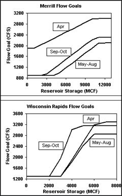
Spring-Summer-Fall (April-October)
Flow goals during spring, summer, and fall are set using rule curves. Rule curves are mathematical formulas that allow WVIC to calculate the flow goals using two factors: date and current storage in the reservoirs. The rule curves vary by month to account for the changes in meteorological and hydrologic conditions that occur between spring, summer, and fall.
The rule curves have a lower bound that is set to protect water quality on the Wisconsin River, since very low flows can result in low dissolved oxygen and poor water quality. As reservoir storage rises above the minimum, flow goals increase because more water is available for flow augmentation. The rule curves also have an upper bound set to conserve water in case drought conditions develop.
During runoff events, river flows can exceed the flow goals for two reasons: 1) the reservoirs may be full and hence unable to store more water, and 2) runoff from the many unregulated rivers that drain into the Wisconsin River are increasing the flow.
Winter
Flow goals during winter are set to reduce storage in the reservoir system to a selected end-of-winter (end of March) target capacity while at the same time providing uniform river flow. This is done by calculating the current usable reservoir storage, proportioning this storage over the number of days until the end of March, and adding this amount to the expected natural river flow for the winter season. This calculation is updated periodically throughout the winter.
Early in the winter season, the end-of-winter target capacity used in the winter flow goal calculation is zero usable storage. The amount of water that is accumulating in the snowpack is monitored throughout the winter season. If the snow water content is running significantly below normal, the end-of-winter target capacity will be raised, and hence the winter flow goal will be lowered. This is done to supplement the spring refill of the reservoir system.
The expected natural flow used in the winter flow goal calculation is initially determined each year using WVIC's Groundwater Index. The expected natural flow is then updated throughout the winter season on the basis of observed natural flow.
WVIC must file an annual report with FERC documenting actual river flows. Any flows that are more than 15% below the flow goals or more than 15% above the flow goal for any reason other than runoff events beyond WVIC's control must be explained.
|
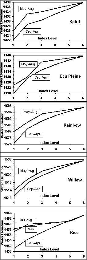
Storage Balancing Using Index Levels
Storage must be balanced between the reservoirs in order to use the total available storage in a hydrologically, environmentally, and recreationally sound manner. The method used to balance storage is to assign six "index levels" to the available storage range in each of the reservoirs and then operate the reservoirs in a manner that keeps all reservoirs as close to the same index level as possible. The index level method of storage balancing has been used by other agencies including the Army Corps of Engineers.
The relationship of the index levels to usable storage and water level varies from reservoir to reservoir. Many factors, including the interrelationships of the reservoirs, the hydrologic characteristics of each reservoir's drainage basin, and each reservoir's individual recreational and environmental resources were considered along with hydropower in setting the proposed index levels.
Here is an example of using index levels to balance storage between reservoirs. During spring runoff the Rainbow, Rice, Spirit, and Eau Pleine reservoirs fill completely, but the Willow reservoir stops filling with the water level still 3 feet below full. Using the index level relationships in the FERC license, WVIC calculates that the Rainbow, Rice, Spirit, and Eau Pleine reservoirs are all at index level 6.0 while the Willow reservoir is at index level 4.2. Since the goal of the operating plan is to keep all reservoirs at the same index level if possible, WVIC will release water from the Rainbow, Rice, Spirit and Eau Pleine reservoirs to meet the flow goals, but will leave the discharge at the Willow reservoir set to the minimum flow. WVIC will not release water from the Willow Reservoir until the water levels in the other reservoirs drop to index level 4.2.
While the goal of the operating plan is to keep the reservoir storages balanced at all times, there are two factors beyond WVIC's control that can put index levels out of balance for short periods of time.
|
 |
|
WVIC must file an annual report with FERC documenting actual index levels. Any index
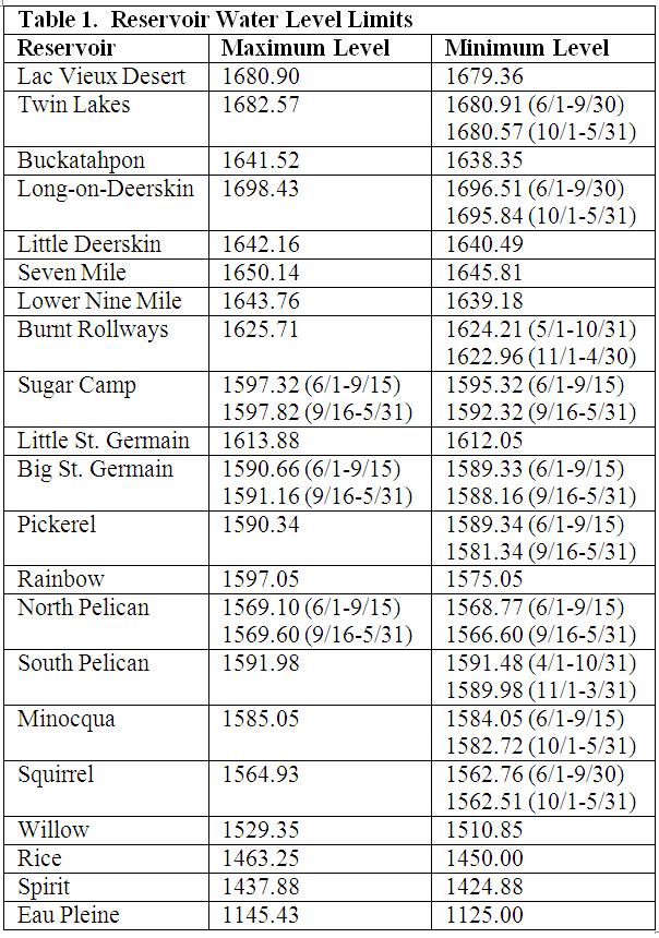
Maximum and Minimum Water Levels in Each Reservoir
Maximum and minimum allowable water levels are specified for each reservoir. These
For some reservoirs the water level limits remain constant throughout the year, while at
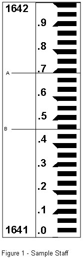
Staff gages are installed on the spillways of each dam that are visible to the public. The
Two sample water level readings are shown on the figure to illustrate the correct
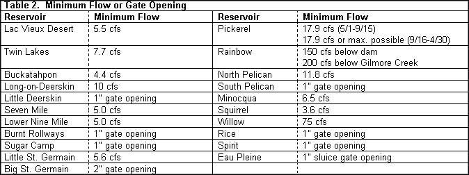
Minimum Flows
Minimum flow is the lowest flow that can be discharged from a dam. Minimum flows are
Minimum flows are measured either in cubic feet per second (cfs) of river flow or in inches
If discharges fall below minimum flow, WVIC must file a written report with FERC that
Table 2 shows the minimum flow or gate opening for each of the 21 WVIC reservoirs.
|
|