|
 -
General Description -
General Description
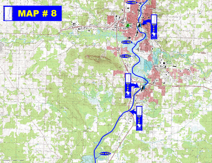
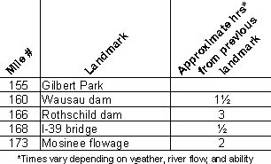
o Miles 155 - 160 (Gilbert Park to Wausau dam) The Wausau flowage
continues through the city of Wausau
o Miles 160 - 166 (Wausau dam to Rothschild dam) River widens into
shallow weedy Lake Wausau with heavy boat traffic
o Miles 166 - 168 (Rothschild dam to I-39 bridge) Noticeable current
in this stretch depends on release from Rothschild dam, river is
deep and navigable by motor boats
o Miles 168 - 173 (I-39 bridge to the Mosinee flowage) Pass by the
Weston Power Plant on the left and continue into the widened floodplain
of the Mosinee flowage
- Portages (see portage maps by clicking on the dam symbol)
o Mile 160 Wausau dam - Take the right channel around Barker/Stewart
Island (the large island after the Bridge Street bridge), after
the second railroad bridge a buoy line guides you to the take-out
on the left shore just above the dam for about a 400' portage around
the Wausau Papers office building (left)
o Mile 166 Rothschild dam - Take out at the wooden steps at the
end of the buoy line and follow the portage signs for about ? mile
to the boat ramp in the tailwater (right)
- Landings suitable for take-out or put-in
o Mile 155 Schofield Park boat landing (right)
o Mile 160 Oak Island boat landing (left) and Riverside Park boat
landing (right)
o Mile 162 Memorial Park boat landing (left) and D.C. Everest Park
boat landing (right)
o Mile 163 Bluegill Bay Park boat landing (right)
o Mile 166 Domtar boat landing in tailwater of Rothschild dam (right)
- Camping - Camping available at Marathon Park (½ mile west
of the river on Stewart Ave.)
- Other amenities
o Mile 155 through Mile 163 - Many businesses in Wausau
o Mile 155 - Schofield Park with boat landing, picnic area with
shelter, ball fields, playground, restroom and water available (right)
o Mile 159 through Mile 161 - Several downtown city parks with many
amenities: boat landing, whitewater kayak & canoe course, restrooms,
playgrounds, ball fields, picnic areas with shelters, trails, ball
fields and courts, and water available at some
o Mile 162 - Memorial Park with boat landing, picnic area with shelters,
disc golf, tennis courts and playground (left)
o Mile 162 - D.C. Everest Park with boat landing, picnic area with
shelter, fishing pier, restrooms and water available (right)
o Mile 163 - Bluegill Bay Park with boat landing, picnic area with
shelters, restrooms, ball courts, trails, playground, fishing pier
and water available (right)
- Flow Information - For flow information on river flow below Wausau go to http://www.wisconsinpublicservice.com/environment/hydrodata.aspx and for river flow below Rothschild go tohttp://waterdata.usgs.gov/wi/nwis/uv/?site_no=05398000&PARAmeter_cd=00065,00060 or go to content.cfm?PageID=84&Cat=0)
|