|
 -
General Description -
General Description
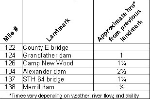
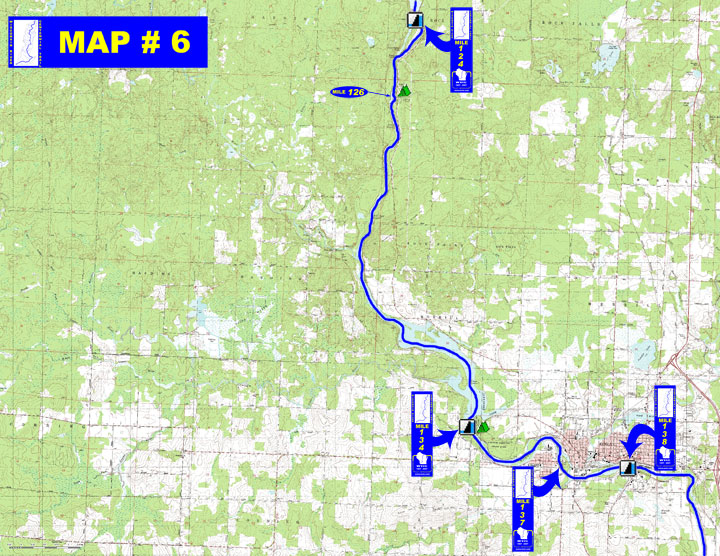
o Miles 122 - 124 (Lincoln County E to Grandfather dam) Go through
the narrow Grandfather Flowage to the diversion channel (canoe trail)
on the left
o Miles 124 - 126 (Grandfather dam to Camp New Wood) Short paddle
with current dependent on release from Grandfather dam
o Miles 126 - 134 (Camp New Wood to Alexander dam) Scenic paddle
through easily navigated Posey Rapids and more challenging Bill
Cross Rapids, then enter Alexander Flowage with heavy boat traffic
o Miles 134 - 137 (Alexander dam to STH 64) An easily navigated
rapids just below the dam, many small islands and another easy rapids
just before the city of Merrill
o Miles 137 - 138 (STH 64 to Merrill dam) Go through residential
& industrial development in the city of Merrill
- Portages (see portage maps by clicking on the dam symbol)
o Mile 124 Grandfather dam - Paddle the diversion channel to a 1/3
mile portage trail (left)
o Mile 134 Alexander dam - Portage around the dam and follow the
trail & a road in Council Grounds State Park for about 800'
to the designated put-in site (left)
o Mile 138 Merrill dam - Portage take-out at the end of a cement
wall to a 600' trail (left)
- Landings suitable for take-out or put-in
o Mile 124 Access below Grandfather dam with parking available (left)
o Mile 126 Camp New Wood County Park boat landing with parking available
(left)
o Mile 131 Lokemoen Road public boat landing (left)
o Mile 134 Council Grounds State Park boat landing (left) &
WPSC boat landing off Sunset Drive (right)
o Mile 137 City of Merrill boat landing at Ott's Park (right)
- Camping
o Mile 126 Lincoln County - Camp New Wood Park with 7 sites
o Mile 134 Wisconsin State Park- Council Grounds with 55 sites
- Other amenities
o Mile 126 - Camp New Wood County Park with water available, boat
landing, restrooms, picnic area & shelters (left)
o Mile 134 - Council Grounds State Park with picnic areas, hiking
trails, restrooms, boat landing, beach & water available (left)
o Mile 137 - Ott's Park with water available, boat landing, restrooms,
ball fields, picnic area & shelter (right)
o Miles 137 through 138 - Many businesses in Merrill
- Flow Information - For flow information on river flow below Grandfather, Alexander and Merrill go to http://www.wisconsinpublicservice.com/environment/hydrodata.aspx.
|


 -
General Description