|
 -
General Description -
General Description
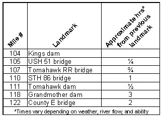
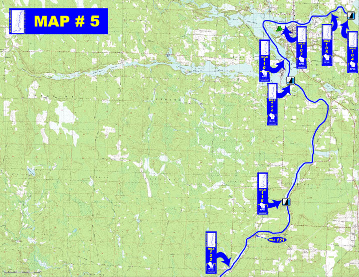
o Miles 104 - 105 (Kings dam to USH 51) Short run of big river paddling
o Miles 105 - 107 (USH 51 to Tomahawk RR bridge) Entrance to Lake
Mohawksin with much development
o Miles 107 - 111 (Tomahawk RR bridge to STH 86) Go through Lake
Mohawksin surrounded by the city of Tomahawk
o Miles 111 - 118 (Tomahawk dam to Grandmother dam) First few miles
have moderately swift current, river gradually widens to the narrow
flowage
o Miles 118 - 122 (Grandmother dam to Lincoln County E) Scenic with
some residential development, no rapids
- Portages (see portage maps by clicking on the dam symbol)
o Mile 111 Tomahawk dam - Take-out at the boat landing and portage
300' to a wooden canoe slide (left)
o Mile 118 Grandmother dam - Take-out at the boat landing and portage
500' to wooden steps below the power house (right)
- Landings suitable for take-out or put-in
o Miles 107 through 108 City of Tomahawk boat landings:
" Kwahomot Ski Park - north side of North Fourth Street bridge
(right)
" SARA Park - north off West Somo Avenue (left)
" Bradley Park - west off Tomahawk Avenue (left)
o Mile 111 Boat landing at portage take-out (left) & Pride Boat
Landing below dam (left)
o Mile 118 Access to boat landing in Grandmother Flowage (portage
take-out) and portage put-in below the dam (right)
o Mile 121 Rock Falls public boat landing off STH 107 (left)
o Mile 122 Lincoln County E bridge access downstream of bridge (right)
- Camping
o Mile 107 City of Tomahawk - SARA Park campground with 10 sites
- Other amenities
o Mile 106 through Mile 110 - Many businesses in Tomahawk
o Mile 106 - Memorial Park with swimming beach, fishing pier &
picnic area (left)
o Mile 107 - SARA Park with boat landing, swimming beach, ball fields,
playground and restrooms (left)
o Mile 108 - Bradley Park with boat landing, playground, picnic
area with shelters, and restrooms (left)
- Flow Information - For flow information on river flow below Tomahawk go to http://www.wisconsinpublicservice.com/environment/hydrodata.aspx.
|


 -
General Description