|
 -
General Description -
General Description
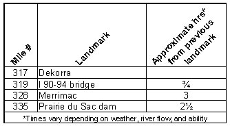
o Miles 317 - 319 (Dekorra to I 90-94 bridge) St. Lawrence Bluff
borders the east shore keeping the river fairly narrow until it
passes under I 90-94 where shoreline development increases and the
river widens as it approaches Lake Wisconsin
o Miles 319 - 328 (I 90-94 bridge to Merrimac) River broadens out
into 9,500 acre Lake Wisconsin where waves from heavy recreational
boat traffic and winds can create challenging conditions for canoeists
o Miles 328 - 335 (Merrimac to Prairie du Sac dam) Lake narrows
at Merrimac the site of the car ferry crossing and continues southwest
to the last dam on the Wisconsin River
- Portages (see portage maps by clicking on the dam symbol)
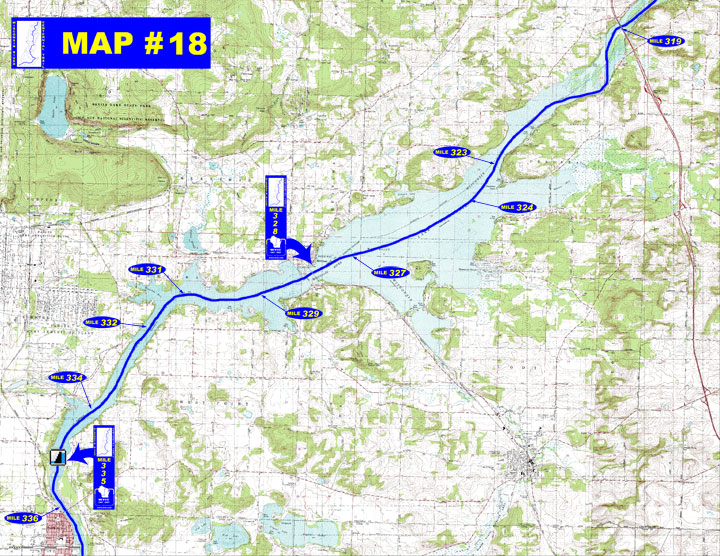
o Mile 335 Prairie du Sac dam - Take-out at some large concrete
steps along a chain linked fence about 400' to the put-in immediately
below the dam into a turbulent tailwater area where there can be
dangerous standing waves depending on discharge (left)
- Landings suitable for take-out or put-in
o Mile 323 - Rest park boat landing (left)
" Happy Hollow boat landing (left)
" Tipperary Point public boat landing (left)
o Mile 324 Perry Camp Landing (left)
o Mile 327 Okee Bay boat landing (left)
o Mile 329 Lake Drive boat landing (left)
o Mile 331 Moon Valley boat landing (right)
o Mile 332 Sauk County public boat landing (right)
- Camping
o Mile 336 VFW - Veteran Memorial Park in Prairie du Sac with 25
camp sites
- Other amenities
o Mile 319 through Mile 335 - Many businesses on Lake
Wisconsin
o Mile 328 - Memorial Park with picnic area with shelter, playground,
restrooms, accessible fishing pier and drinking water available
" Businesses in the Town
of Merrimac and Village
of Merrimac (right)
o Mile 336 - Veteran Memorial Park with boat landing, campground,
picnic area with shelters, playground, restrooms and drinking water
available on the eastside of the clubhouse (right)
- Flow Information - For information on river flow near Portage on this website go to Flow Forecasts under Wisconsin River /content.cfm?PageID=84&Cat=0 and for information on river flow below Prairie du Sac go to https://www.alliantenergy.com/SaveEnergyAndMoney/RenewableEnergy/FlowRate/index.htm.
|


 -
General Description