|
 -
General Description -
General Description
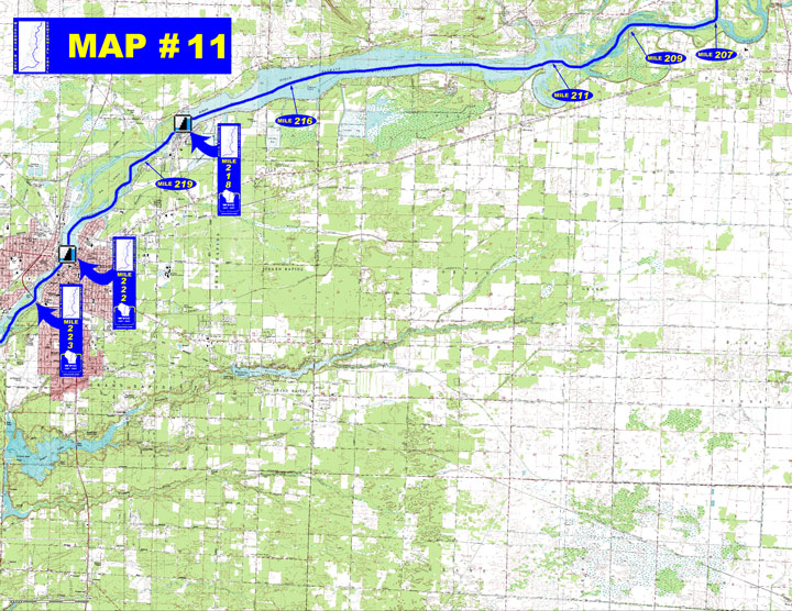
o Miles 206 – 211 (Whiting Plover portage to Biron flowage)
Carefully navigate fast water and rocks below the dam. Stay to the
right of the group of large islands for the shortest route. Rocky
Run and Mill creeks empty in on the right marking the upper end
of Biron flowage.
o Miles 211 – 218 (Biron flowage to Biron dam) Lake canoeing
in the narrow 2,078 acre, 7 mile long flowage
o Miles 218 – 222 (Biron dam to Wisconsin Rapids dam) Go around
either side of Big Island, the channel is on the left but the right
shoreline is more scenic
o Miles 222 – 223 (Wisconsin Rapids dam to Expressway bridge)
The river continues through the city of Wisconsin Rapids with numerous
islands in this section
- Portages (see portage maps by clicking on the dam symbol)
o Mile 218 Biron dam – Take-out on the steep riprapped bank
and proceed down the dike to a trail for a ¼ mile portage
into the right channel (right)
o Mile 222 Wisconsin Rapids dam – Take-out upstream of the
railroad bridge to begin the over 1 mile long portage through Wisconsin
Rapids to the put-in next to the Elks Club (a map is posted at the
take-out) OR call for assistance (715)422-3303 but be aware that
it might take some time dispatching a vehicle (left)
- Landings suitable for take-out or put-in
o Mile 207 Blue Heron Lane boat landing (right)
o Mile 209 Galecke Park boat landing (left)
o Mile 216 – North Biron Drive boat landing (left)
- River Road boat landing (right)
o Mile 219 South Biron Drive boat landing (left)
(More access sites available on
Biron Flowage & Wisconsin
Rapids Flowage)
- Camping
o Mile 211 Private campground – “Ridgewood Campground
(715-344-8750)” (left)
- Other amenities
o Mile 209 – Galecke Park with boat landing, beach and picnic
o Mile 219 – South Biron Drive with boat landing and accessible
fishing pier (left)
o Mile 220 through Mile 224 – Many businesses in Wisconsin
Rapids and Wisconsin
Rapids surrounding area.
- Flow Information – For flow information on river flow below Wisconsin Rapids go to http://www.cwpco.com/CWPCoDB/Daily_River_Report.aspx” or on this website go to Flow Forecasts under Wisconsin River http://wvic.bigfatdev.com/content.cfm?PageID=84&Cat=0 or go to content.cfm?PageID=84&Cat=0
|


 -
General Description