- General Description
MAP #10 – DuBay Dam to Whiting Plover Portage
- General Description
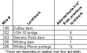
o Miles 190 – 202 (DuBay dam to USH 10 bridge) First 6-7 miles
is riverine turning into lake canoeing in the 3,915 acre Stevens
Point Flowage through the city of Stevens Point
o Miles 202 – 203 (USH 10 bridge to Stevens Point dam) Pass
under the highway bridge to the portage on the right
o Miles 203 – 205 (Stevens Point dam to Whiting dam) Relatively
undeveloped narrow and swift section
o Miles 205 – 206 (Whiting dam to Whiting Plover portage)
Short shallow, rocky stretch between dams is often portaged
- Portages (see portage maps by clicking on the dam symbol)
o Mile 203 Stevens Point dam - Take-out at the dike and follow the
dirt road for about 1000' to the put-in just below the dam (right)
o Mile 205 Whiting dam - Take-out where the power lines cross the
river, follow the dirt road to River Road then left to the put-in
for about a ¼ mile long portage OR continue on River Rd to
the Whiting Plover (Al Tech) put-in for a portage just under 1 mile
long (right)
o Mile 206 Whiting Plover portage - Take-out at a marked grassy
area and follow the signed trail to River Road for less than ¼
mile to the put-in at Al Tech Park (right)
- Landings suitable for take-out or put-in
o Mile 197 USH 10 Landing (right)
o Mile 201 Bukolt Park boat landing (left)
o Mile 202 Pfiffner Pioneer Park boat landing (left)
(More access sites available on Stevens
Point Flowage)
- Camping
o Mile 192 Private campground - "River's Edge Campground"
(715-344-8058) (left)
- Other amenities
o Mile 201 through Mile 205 - Many businesses in Stevens
Point and the Stevens Point
surrounding area
o Mile 201 - Bukolt Park with boat landing, ball fields, restrooms,
picnic area, beach and playground (left)
o Mile 202 - Mead Park with ball fields, ball courts, restrooms,
picnic areas with shelter, beach, disc golf and playground (right)
" Pfiffner Pioneer Park with boat landing, boat slips, trails,
restrooms, picnic area and playground (left)
o Mile 203 - Consolidated Parkway with picnic areas, canoe and fishing
access (right)
o Mile 206 - Al Tech Park with picnic area, canoe and fishing access
(right)
- Flow Information - For flow information on river flow below Stevens Point go to http://www.cwpco.com/CWPCoDB/Daily_River_Report.aspx.
|


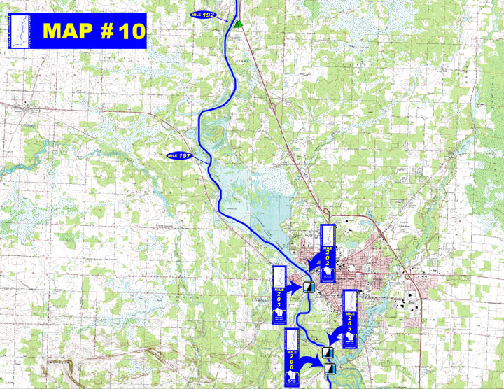
 on the map below for a aerial photographic detail of portage.